


08
Dec
Rock Loop Walk
The first trail marked in Green is an easy 3km loop walk of thirty minutes on roadway past St Coumghall’s Church.
Distinguishing features on this trail include two examples of Wedge Tombs or Domans at Kilkileen and Bawngare. Further North at Kilsarlaught lays

08
Dec
Ilen River Loop Walk
This is an easy loop walk lasting two hours. It offers excellent views of the tidal Ilen River in its many phases.
Lough Ine hill, and the Beacon in Baltimore can be viewed as the walker turns left at Minihan’s Pub and travels

08
Dec
Becher’s Loop Walk
This Loop Walk along quiet tarred roads, departs from the trailhead towards Aughadown Creamery shop.
Take the second right then after a steep incline the walker can see The Gazebo in a field on the right. Evidence shows that this structure was a

04
Jan
Kilcoe to Skibbereen Linear Walk
This linear walk of 12 km completes the walk from the Mizen to Skibbereen. It begins at the Kilcoe Trail Head and follows rural back-roads, passing by two large Standing Stones or Galaun and key landmarks like the Great Famine Plot in

08
Dec
Lisheenacrehig Loop Walk
Keep right by the Church and crossing the N71 with extreme care walk on the right to the 2nd junction, and head north at the sign for Corravoley, following the green arrows.
Behind the former pub known as “The Cross House” lies the

08
Dec
Derreenard Loop Walk
Head back out on the N71 and crossing with extreme care head east.
Leaving the N71 two standing stones, known as “The Gullanes”, can be seen 1 ½ miles away on the horizon in Toormore. The same distance away is a Cairn (a

08
Dec
Ballydehob Linear Walk
This 6.5km linear walk to Ballydehob takes you south by the Church built in 1905 to Roaring Water Pier before directing you back 150m to head west.
A Feature of this walk are the options southward to visit some old piers built during

08
Dec
Butter Road Walk
This 10km linear walk joins an old 17th century road at the half way mark. Known as the Bridle Road (or the Butter Road), this old green lane stretches from Kilbronogue to the Mill House near Schull. It is advisable to wear

02
Jan
Rossbrin Loop Walk
A scenic coastal walk of about 11.5 km on tarred surfaces.
Leave by the footpath at the back of the tennis courts, rise to Greenmount Road and turning left go 3.5km south to reach the old Stouke Graveyard. Follow the purple arrows and
01
Jan
Kilcoe Linear Walk
This 6.5km linear walk to Kilcoe crosses over the 12-arch bridge and heads east.
Take extreme care as you walk along side of the busy N71 for a short while before turning off at Skeaghnore cross. The walker is given options to go

15
Dec
Derryconnell Loop Walk
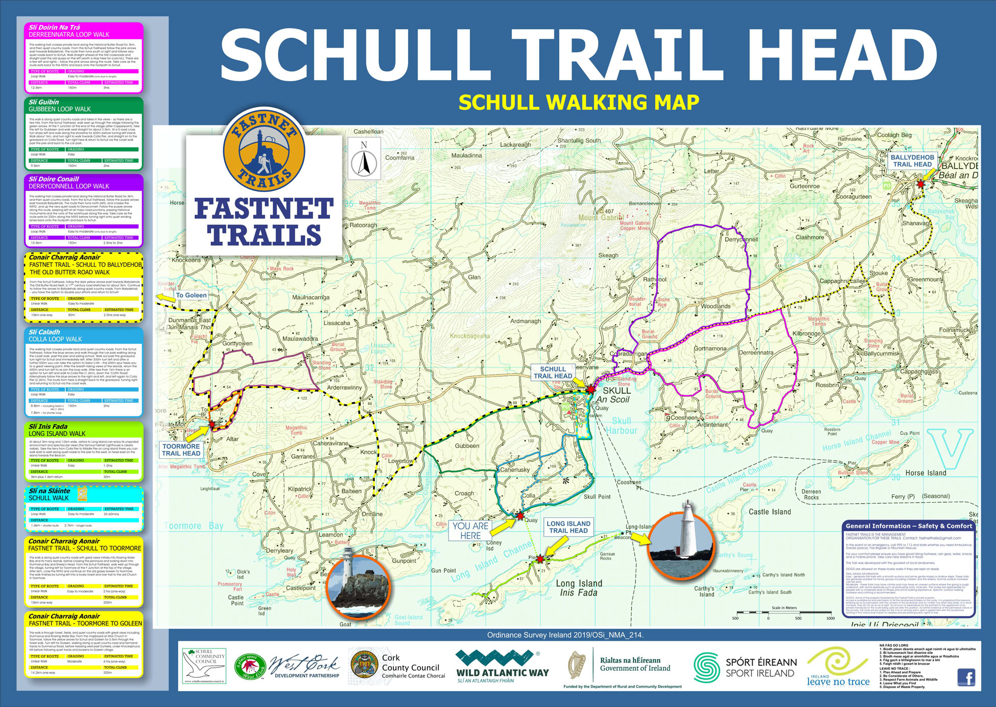
This walking trail crosses private land along the historical Butter Road for 3km and then quiet country roads. From the mapboard, follow the purple arrows east towards Ballydehob. The route then turns north (left), and crosses the N592, and up the very

01
Dec
The Old Butter Road Walk
From the mapboard, follow the dark yellow arrows east towards Ballydehob. The Old Butter Road itself, a 17th century road stretches for about 3km. Continue to follow the arrows to Ballydehob along quiet country roads. From Ballydehob – you have the option

20
Nov
Gubbeen Loop Walk
This walk is along quiet country roads and takes in the view – so there are a few hills. From the mapboard, walk west up through the village following the green arrows. At the Y Junction at the end of the village
10
Nov
Derreennatra Loop Walk
This walking trail crosses private land along the historical Butter Road for 3km, and then quiet country roads. From the mapboard, follow the pink arrows east towards Ballydehob. The route then turns south or right and follows very quiet roads back to

24
Oct
Colla Loop Walk
This walking trail crosses private land and quiet country roads. From the mapboard, follow the blue arrows and walk through the car park walking along the coast walk, past the pier and sailing school. Walk out past the graveyard, turn right for

22
Aug
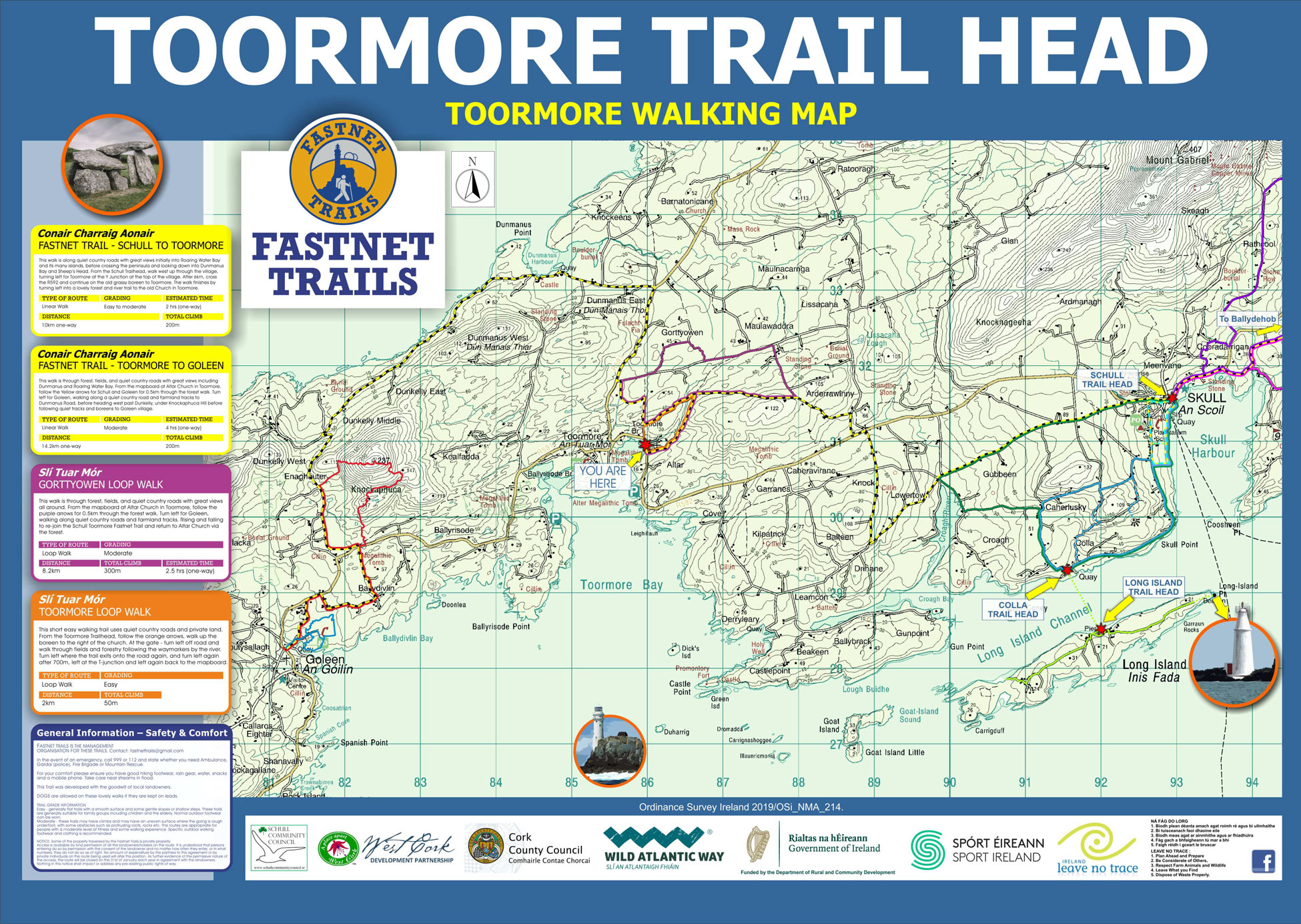
Schull to Toormore Walk
This walk is along quiet country roads with great views initially into Roaring Water Bay and its many islands, befor crossing the peninsula and looking down into Dunmanus Bay and Sheep’s Head.

28
Feb
Toormore – Barr an Bheallaigh Link Walk
This long linear walk of 18.5 km extends from the Toormore Trail Head to the Barr an Bheallaigh carpark/layby on the eastern side of Mount Corrin. It links the Fastnet Trails Walks to the Sheep's Head Way.

16
Aug
Toormore to Schull Walk
At the Toormore Trailhead follow the track to the right of Altar Church through the grassy woodland trail.

08
Aug
Toormore Loop Walk
Toormore is located 10km from Schull on the main road to Goleen. This walk starts and finishes at the old Toormore Church where a mapboard

02
Aug
Gortyowen Loop
This walk is through forest, fields, and quiet country roads with great views all around. From the mapboard at Altar Church in Toomore, follow the purple arrows for 0.5km through the forest walk. Turn left for Goleen, walking along quiet country roads

09
Jul
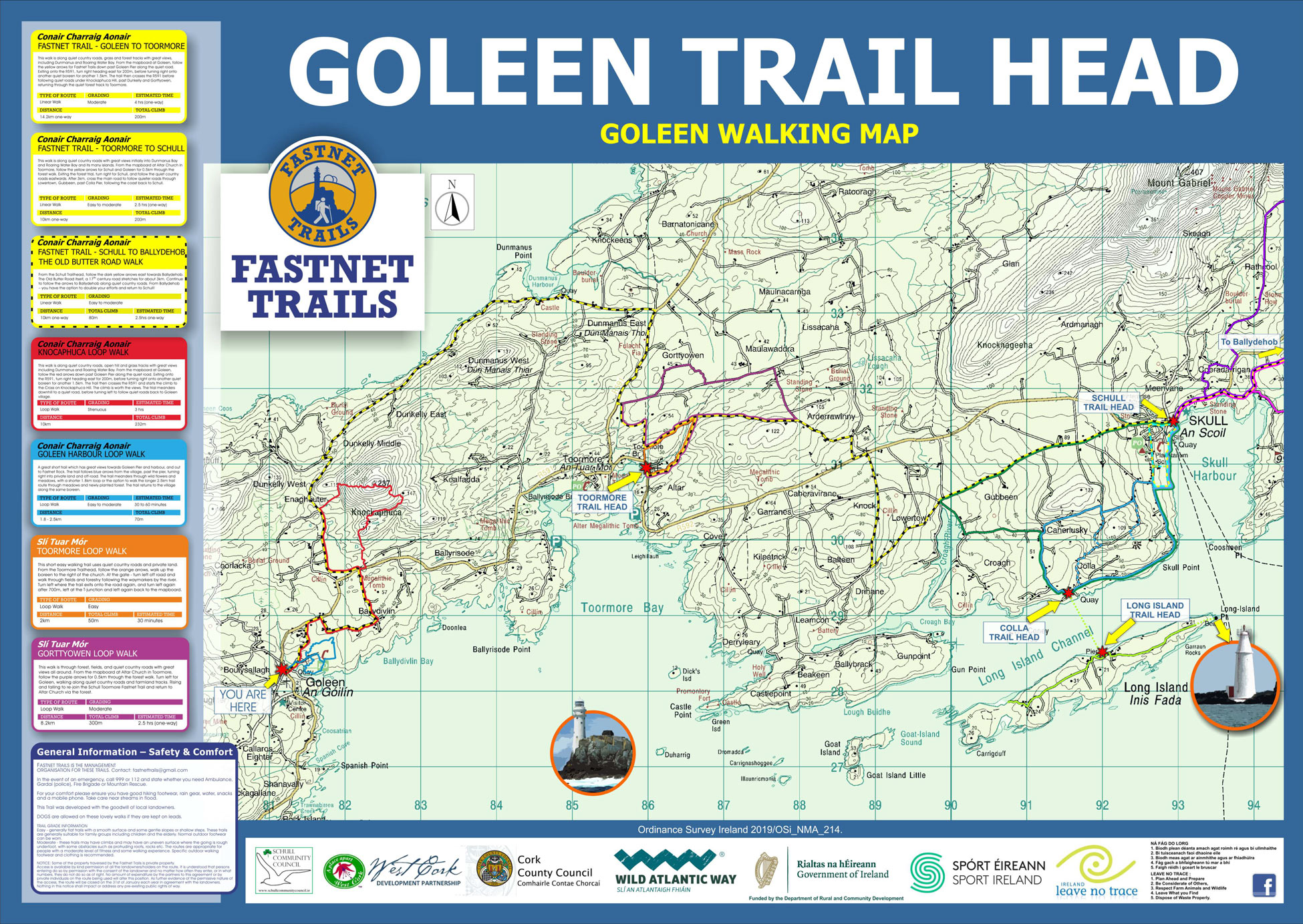
Toormore to Goleen Walk
This walk is through forest, fields, and quiet country roads with great views including Dunmanus and Roaring Water Bays. From the mapboard at Altar Church in Toormore

21
Mar
Gortdubh Loop Walk
This rather long 14km walk starts from the Goleen village Trailhead or the Community Centre Trailhead by following the green arrows. After making your way west long a quiet backroad you will take a sharp right as you see views to the

21
Mar
Lissigriffin Loop Walk
A 10km walk along very quiet backroads rising above Goleen to the west with views right out over Lissigriffin lake and away to the west towards Barley cover. From the Goleen village mapboard follow the purple arrows and head up past the

21
Mar
Goleen Harbour Loop Walk
A lovely loop walk around the east side of Goleen Harbour with views of the village, the outer pier and out to the Fastnet Rock, the islands and towards Crookhaven. The trail follows blue arrows from the village before turning into Goleen

21
Mar
Knockaphuca Loop Walk
This walk is on quiet country roads, open hill and grass tracks with great views of rolling hills and both Dunmanys and Roaring Water Bay. From the mapboard at Goleen, follow the red arrows down past Goleen Pier along the quiet road.
21
Mar
Goleen to Toormore Loop Walk
This walk is along quiet country roads and forest tracks with great views, which include Dunmanus and Roaring Water Bay. From the mapboard at Goleen, follow the yellow arrows for Fastnet Trails down past Goleen Pier, and on along a quiet boreen.
21
Mar
Gortdubh Loop Walk
This rather long 14km walk starts from the Goleen village Trailhead or the Community Centre Trailhead by following the green arrows. After making your way west long a quiet backroad you will take a sharp right as you see views to the
21
Mar
Lissigriffin Loop Walk
A 10km walk along very quiet backroads rising above Goleen to the west with views right out over Lissigriffin lake and away to the west towards Barley cover. From the Goleen village mapboard follow the purple arrows and head up past the